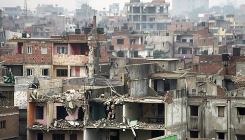
Seismic activity
Introduction
Seismic activity refers to the types, frequency, and magnitude of earthquakes that occur over a period of time in a certain area. It is a critical aspect of geophysics and seismology, the scientific study of earthquakes and the propagation of elastic waves through the Earth or other planet-like bodies. Understanding seismic activity is essential for assessing earthquake hazards, implementing building codes, and preparing for potential natural disasters.
Causes of Seismic Activity
Seismic activity is primarily caused by the sudden release of energy in the Earth's crust that creates seismic waves. This energy release is often due to the movement of tectonic plates, which are large sections of the Earth's lithosphere that move and interact at their boundaries. The primary causes of seismic activity include:
Tectonic Earthquakes
Tectonic earthquakes occur when stress accumulated along geological faults is released. These faults are fractures in the Earth's crust where blocks of rock have moved past each other. The most significant tectonic earthquakes are associated with subduction zones, where one tectonic plate is forced beneath another, and transform boundaries, where plates slide past each other horizontally.
Volcanic Earthquakes
Volcanic earthquakes are caused by the movement of magma within the Earth's crust. As magma rises towards the surface, it can cause the surrounding rock to crack and create seismic waves. These earthquakes are typically smaller in magnitude but can be a precursor to volcanic eruptions.
Induced Seismicity
Induced seismicity refers to earthquakes that result from human activities, such as mining, reservoir-induced seismicity from filling large reservoirs, geothermal energy extraction, and hydraulic fracturing (fracking). These activities can alter the stress conditions in the Earth's crust, leading to seismic events.


Measurement and Detection
Seismic activity is measured using seismometers, which detect and record the motion of the ground. The data collected by seismometers are used to determine the location, depth, and magnitude of an earthquake.
Magnitude
The magnitude of an earthquake is a measure of the energy released at the source of the earthquake. It is commonly measured using the Richter scale or the moment magnitude scale (Mw). The moment magnitude scale is more accurate for large earthquakes and has largely replaced the Richter scale in scientific use.
Intensity
The intensity of an earthquake measures the effects of the earthquake at different locations on the Earth's surface. It is commonly measured using the Modified Mercalli Intensity scale (MMI), which ranges from I (not felt) to XII (total destruction).
Seismic Waves
Seismic waves are the energy waves that travel through the Earth as a result of an earthquake. There are two main types of seismic waves: body waves and surface waves. Body waves include P-waves (primary waves) and S-waves (secondary waves), while surface waves include Love waves and Rayleigh waves.
Seismic Zones and Hazard Assessment
Seismic zones are regions of the Earth that are prone to earthquakes. These zones are typically located along tectonic plate boundaries. Some of the most seismically active regions in the world include the Ring of Fire, the Himalayan region, and the San Andreas Fault in California.
Seismic Hazard Assessment
Seismic hazard assessment involves evaluating the probability of earthquake occurrence and the potential ground shaking intensity in a specific area. This assessment is crucial for designing earthquake-resistant structures and for urban planning in earthquake-prone regions. It involves the analysis of historical earthquake data, geological studies, and the use of probabilistic seismic hazard analysis (PSHA) models.
Earthquake Prediction and Early Warning Systems
Predicting the exact time and location of an earthquake remains a significant challenge in seismology. However, scientists can estimate the likelihood of future earthquakes based on historical data and geological studies.
Earthquake Prediction
Earthquake prediction involves forecasting the time, location, and magnitude of future earthquakes. While short-term prediction remains elusive, long-term forecasts can provide valuable information for preparedness and mitigation efforts.
Early Warning Systems
Early warning systems aim to provide advance notice of an impending earthquake, allowing people to take protective actions. These systems use real-time data from seismometers to detect the initial P-waves of an earthquake and send alerts before the more damaging S-waves and surface waves arrive. Countries like Japan and Mexico have implemented advanced earthquake early warning systems.
Mitigation and Preparedness
Mitigating the impacts of seismic activity involves a combination of engineering, policy, and public education.
Earthquake-Resistant Design
Building structures to withstand seismic forces is a critical aspect of earthquake mitigation. This involves the use of seismic design principles, such as base isolation, energy dissipation devices, and flexible building materials. Building codes and standards, such as the International Building Code (IBC), provide guidelines for designing earthquake-resistant structures.
Emergency Preparedness
Public education and emergency preparedness are essential for reducing the impacts of earthquakes. This includes conducting earthquake drills, developing emergency response plans, and ensuring that communities have access to emergency supplies and information.
