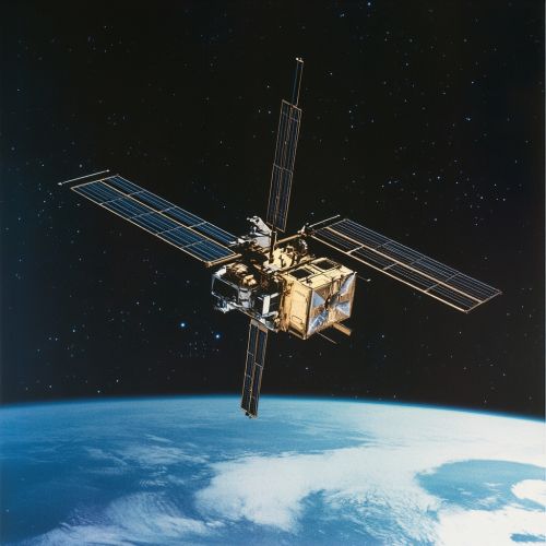
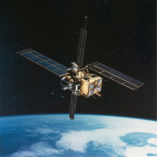
RADARSAT
Overview
The RADARSAT program is a series of Canadian remote sensing satellites developed and operated by the Canadian Space Agency (CSA). The primary objective of the RADARSAT program is to provide high-resolution synthetic-aperture radar (SAR) imagery for a variety of applications, including environmental monitoring, resource management, and national security. The program has been instrumental in advancing Canada's capabilities in space-based radar technology and has significantly contributed to global remote sensing efforts.
History and Development
The RADARSAT program began in the early 1980s as a response to the growing need for reliable and timely Earth observation data. The Canadian government, recognizing the strategic importance of space-based radar technology, allocated funding for the development of the first RADARSAT satellite. The program was designed to leverage Canada's expertise in radar technology and to establish the country as a leader in remote sensing.
RADARSAT-1


Launched on November 4, 1995, RADARSAT-1 was Canada's first Earth observation satellite equipped with SAR technology. The satellite was designed to provide all-weather, day-and-night imaging capabilities, making it particularly useful for monitoring Canada's vast and often cloud-covered territory. RADARSAT-1 operated in multiple imaging modes, offering different resolutions and swath widths to meet various user needs.
The satellite's SAR instrument operated in the C-band frequency, which is well-suited for penetrating clouds and vegetation. This capability made RADARSAT-1 invaluable for applications such as agriculture, forestry, ice monitoring, and disaster management. The satellite exceeded its expected lifespan, operating successfully for 17 years before being decommissioned in 2013.
RADARSAT-2
Building on the success of RADARSAT-1, RADARSAT-2 was launched on December 14, 2007. This second-generation satellite featured several technological advancements, including higher resolution imaging, improved data quality, and increased operational flexibility. RADARSAT-2's SAR instrument could operate in multiple polarization modes, allowing for more detailed analysis of surface features.
One of the key innovations of RADARSAT-2 was its ability to collect fully polarimetric data, which provides additional information about the Earth's surface and can be used to distinguish between different types of vegetation, soil moisture levels, and man-made structures. The satellite also introduced new imaging modes, such as the Spotlight mode, which offers very high-resolution images over small areas.
RADARSAT-2 has been widely used for applications in marine surveillance, oil spill detection, urban planning, and climate change research. The satellite continues to operate and provide valuable data to users around the world.
RADARSAT Constellation Mission (RCM)
The RADARSAT Constellation Mission (RCM) represents the next phase of the RADARSAT program. Launched on June 12, 2019, the RCM consists of three identical satellites operating in a constellation. This configuration allows for more frequent revisits and improved coverage, enhancing the program's ability to monitor dynamic and rapidly changing phenomena.
The RCM satellites are equipped with advanced SAR instruments that offer multiple imaging modes and polarizations. The constellation's design enables daily coverage of Canada's land and maritime areas, making it a powerful tool for applications such as maritime surveillance, ecosystem monitoring, and disaster response. The RCM also supports international efforts in humanitarian aid and environmental protection.
Technical Specifications
The RADARSAT satellites are equipped with sophisticated SAR instruments that operate in the C-band frequency range. This section provides detailed technical specifications for each satellite in the RADARSAT program.
RADARSAT-1 Specifications
- **Launch Date:** November 4, 1995 - **Orbit:** Sun-synchronous - **Altitude:** 798 km - **SAR Frequency:** C-band (5.3 GHz) - **Imaging Modes:** Standard, Wide, Fine, Extended High, Extended Low, ScanSAR Narrow, ScanSAR Wide - **Resolution:** 8 to 100 meters - **Swath Width:** 50 to 500 km - **Polarization:** Single (HH)
RADARSAT-2 Specifications
- **Launch Date:** December 14, 2007 - **Orbit:** Sun-synchronous - **Altitude:** 798 km - **SAR Frequency:** C-band (5.405 GHz) - **Imaging Modes:** Spotlight, Ultra-Fine, Multi-Look Fine, Fine, Standard, Wide, ScanSAR Narrow, ScanSAR Wide - **Resolution:** 1 to 100 meters - **Swath Width:** 20 to 500 km - **Polarization:** Single (HH, HV, VH, VV), Dual, Quad
RADARSAT Constellation Mission (RCM) Specifications
- **Launch Date:** June 12, 2019 - **Orbit:** Sun-synchronous - **Altitude:** 600 km - **SAR Frequency:** C-band (5.405 GHz) - **Imaging Modes:** Spotlight, Ultra-Fine, Multi-Look Fine, Fine, Standard, Wide, ScanSAR Narrow, ScanSAR Wide - **Resolution:** 1 to 100 meters - **Swath Width:** 20 to 500 km - **Polarization:** Single, Dual, Compact, Quad
Applications
The RADARSAT program has been instrumental in advancing the field of remote sensing and has provided valuable data for a wide range of applications. This section highlights some of the key uses of RADARSAT imagery.
Environmental Monitoring
RADARSAT satellites have been extensively used for environmental monitoring, including the tracking of deforestation, wetland mapping, and coastal erosion assessment. The ability to penetrate clouds and operate in all weather conditions makes RADARSAT imagery particularly valuable for monitoring remote and often cloud-covered regions.
Agriculture
In agriculture, RADARSAT data is used to monitor crop health, estimate yield, and manage irrigation. The SAR technology can detect changes in soil moisture and vegetation structure, providing critical information for precision farming practices.
Forestry
RADARSAT imagery is used to monitor forest health, map forest cover, and assess the impact of logging activities. The data can also be used to detect and monitor forest fires, providing valuable information for fire management and mitigation efforts.
Ice Monitoring
One of the key applications of RADARSAT is ice monitoring, particularly in the Arctic and Antarctic regions. The SAR technology can penetrate ice and snow, providing detailed information on ice thickness, extent, and movement. This data is crucial for navigation, climate research, and environmental protection.
Disaster Management
RADARSAT data is used in disaster management to assess the impact of natural disasters such as floods, earthquakes, and hurricanes. The imagery can be used to map affected areas, monitor recovery efforts, and plan for future disaster mitigation.
Maritime Surveillance
The RADARSAT program plays a critical role in maritime surveillance, including the monitoring of ship traffic, detection of illegal fishing activities, and tracking of oil spills. The SAR technology can detect vessels and other objects on the water surface, providing valuable information for maritime security and environmental protection.
Future Developments
The success of the RADARSAT program has paved the way for future developments in space-based radar technology. The Canadian Space Agency is actively exploring new technologies and mission concepts to further enhance Canada's capabilities in remote sensing.
One of the key areas of focus is the development of next-generation SAR instruments with higher resolution, improved data quality, and increased operational flexibility. The CSA is also exploring the use of small satellites and constellations to provide more frequent and comprehensive coverage of the Earth's surface.
See Also
- Earth observation satellite
- Synthetic-aperture radar
- Canadian Space Agency
- Remote sensing
- Sun-synchronous orbit
