Mount Tambora
Introduction
Mount Tambora is an active stratovolcano located on the island of Sumbawa in Indonesia. It is part of the Sunda Arc, a volcanic arc that results from the subduction of the Indo-Australian Plate beneath the Eurasian Plate. Tambora is best known for its catastrophic eruption in April 1815, which is considered one of the most powerful volcanic events in recorded history. This eruption had significant global climatic effects and led to what is known as the "Year Without a Summer" in 1816.
Geological Setting
Mount Tambora is situated within the Lesser Sunda Islands, which are part of the Sunda Arc. The arc extends from the Andaman Islands in the northwest to the Banda Sea in the southeast. The region is characterized by complex tectonic interactions, including subduction, volcanic activity, and crustal deformation.
Tectonic Framework
The Sunda Arc is formed by the subduction of the Indo-Australian Plate beneath the Eurasian Plate. This subduction zone is responsible for the formation of numerous volcanoes, including Tambora. The arc is also associated with significant seismic activity, including frequent earthquakes and tsunamis.
Volcanic Structure
Tambora is a stratovolcano, characterized by its steep profile and periodic explosive eruptions. The volcano is composed of alternating layers of lava flows, volcanic ash, and pyroclastic deposits. The summit of Tambora features a large caldera, approximately 6 kilometers in diameter, which was formed during the 1815 eruption.
Eruption History
Mount Tambora has a long history of volcanic activity, with several significant eruptions occurring over the past few thousand years. The most notable eruption occurred in April 1815, which had profound local and global impacts.
Pre-1815 Activity
Prior to the 1815 eruption, Tambora had experienced several smaller eruptions. Geological evidence suggests that the volcano had been relatively quiet for several centuries before the catastrophic event. However, signs of increased activity, such as fumarolic emissions and minor eruptions, were observed in the years leading up to 1815.
The 1815 Eruption
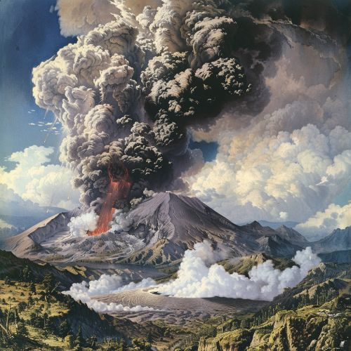
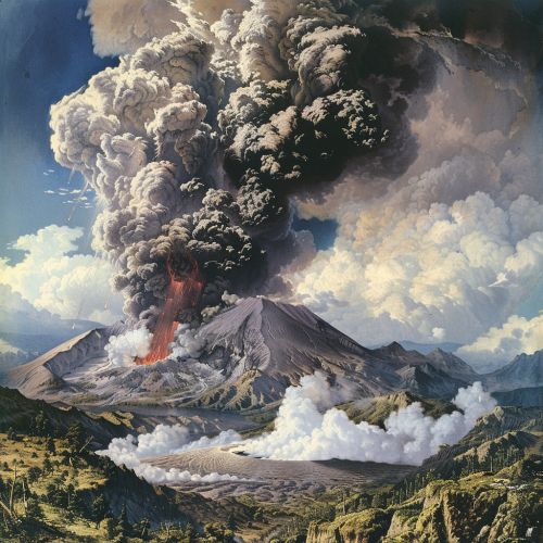
The eruption of Mount Tambora in April 1815 is considered one of the most powerful volcanic events in recorded history. The eruption began on April 5, 1815, with a series of explosive blasts that continued for several days. The main eruption occurred on April 10, producing a massive column of volcanic ash and gases that reached the stratosphere.
The eruption released an estimated 160 cubic kilometers of volcanic material, including ash, pumice, and pyroclastic flows. The explosion was heard as far away as Sumatra, over 2,000 kilometers from the volcano. The eruption caused the collapse of the summit, forming a caldera and resulting in significant topographic changes.


Climatic Impact
The 1815 eruption of Mount Tambora had significant climatic effects, leading to what is known as the "Year Without a Summer" in 1816. The massive amount of volcanic ash and sulfur dioxide injected into the stratosphere led to a reduction in global temperatures. This resulted in widespread crop failures, food shortages, and unusual weather patterns across the Northern Hemisphere.
Environmental and Ecological Impact
The eruption of Mount Tambora had profound environmental and ecological consequences, both locally and globally.
Local Impact
The immediate vicinity of Mount Tambora was devastated by the eruption. The pyroclastic flows and ashfall destroyed villages, forests, and agricultural lands. It is estimated that around 10,000 people were killed directly by the eruption, with many more succumbing to starvation and disease in the aftermath.
Global Impact
The climatic effects of the eruption had far-reaching consequences. The "Year Without a Summer" led to widespread crop failures and food shortages in Europe and North America. The resulting famine and social unrest had significant historical implications, including contributing to the westward migration in the United States and influencing European political events.
Volcanological Studies
Mount Tambora has been the subject of extensive volcanological studies, aimed at understanding the mechanisms and impacts of its eruptions.
Eruption Mechanisms
Studies of the 1815 eruption have provided valuable insights into the eruption mechanisms of stratovolcanoes. The eruption was driven by the rapid ascent of magma, which led to the explosive release of volcanic gases and the fragmentation of the magma into ash and pumice.
Climatic Modeling
The climatic impact of the 1815 eruption has been studied using various climatic models. These models have helped to quantify the extent of the temperature reduction and the distribution of volcanic aerosols in the atmosphere. The findings have implications for understanding the potential climatic effects of future large-scale volcanic eruptions.
Modern Monitoring and Risk Mitigation
Mount Tambora remains an active volcano, and modern monitoring efforts are focused on assessing the potential risks of future eruptions.
Monitoring Techniques
Various monitoring techniques are employed to track volcanic activity at Tambora. These include seismology, gas emissions monitoring, ground deformation measurements, and satellite observations. These techniques provide valuable data for assessing the likelihood of future eruptions and for issuing timely warnings.
Risk Mitigation Strategies
Risk mitigation strategies for Mount Tambora involve both local and regional efforts. These include the development of evacuation plans, public education campaigns, and the establishment of exclusion zones around the volcano. International collaboration is also essential for sharing data and expertise in volcanic risk management.
