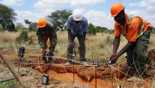
Electrical Resistivity Tomography
Introduction
Electrical Resistivity Tomography (ERT) is a geophysical technique for imaging sub-surface structures from electrical resistivity measurements made at the surface, or by electrodes in one or more boreholes. It is a non-invasive method that allows for detailed imaging and characterization of the subsurface, providing a significant advantage over traditional surveying methods. ERT is widely used in a variety of applications, including environmental studies, mining, archaeology, and hydrogeology.
Principles of Electrical Resistivity Tomography
ERT is based on the principle of Ohm’s Law, which states that the current through a conductor between two points is directly proportional to the voltage across the two points. The resistivity of the subsurface material is determined by measuring the potential difference (voltage) between two electrodes while a current is being applied through two other electrodes. The resulting measurements are then used to create a model of the subsurface resistivity.
Methodology
The ERT survey begins with the placement of electrodes along the ground surface or in boreholes. The configuration of these electrodes can vary depending on the specific requirements of the survey. Common configurations include the Wenner array, the Schlumberger array, and the dipole-dipole array.
Once the electrodes are in place, a current is applied to the outermost pair of electrodes, and the resulting potential difference is measured between the inner pairs. This process is repeated for different combinations of electrodes, resulting in a large number of measurements. These measurements are then processed using a technique known as inversion to produce a model of the subsurface resistivity.


Applications
ERT has a wide range of applications in various fields. In environmental studies, it is used to detect and map contamination plumes, to study the movement of water in the subsurface, and to investigate landfill sites. In mining, it is used to detect and delineate ore bodies, to monitor the stability of mine workings, and to investigate the hydrogeological conditions around mines. In archaeology, ERT is used to detect and map buried archaeological features without disturbing the site. In hydrogeology, it is used to study the distribution of groundwater and the movement of contaminants.
Advantages and Limitations
ERT offers several advantages over traditional surveying methods. It is non-invasive, meaning that it does not disturb the subsurface. It provides detailed images of the subsurface, allowing for a better understanding of the geology and hydrogeology. It is also relatively inexpensive compared to other geophysical methods.
However, ERT also has several limitations. It is sensitive to noise, such as that caused by electrical power lines or metallic objects in the ground. It requires a good electrical contact between the electrodes and the ground, which can be difficult to achieve in dry or frozen conditions. The depth of investigation is limited by the electrode spacing and the resistivity of the subsurface material.
Future Directions
As technology continues to advance, the capabilities of ERT are expected to improve. Future developments may include the use of more advanced inversion algorithms, the integration of ERT with other geophysical methods, and the development of more efficient and accurate data acquisition systems.
