Portolan chart: Difference between revisions
(Created page with "==History== The Portolan charts are a type of nautical chart, first made in the 13th century in the Mediterranean region. These charts, known for their distinctive radiating lines, were used extensively during the Age of Discovery for navigation. They were a significant improvement over the earlier Mappa Mundi style maps, which were more symbolic than accurate. <div class='only_on_desktop image-preview'><div class='image-preview-loader...") |
No edit summary |
||
| Line 2: | Line 2: | ||
The [[Portolan chart|Portolan charts]] are a type of nautical chart, first made in the 13th century in the Mediterranean region. These charts, known for their distinctive radiating lines, were used extensively during the Age of Discovery for navigation. They were a significant improvement over the earlier [[Mappa Mundi|Mappa Mundi style maps]], which were more symbolic than accurate. | The [[Portolan chart|Portolan charts]] are a type of nautical chart, first made in the 13th century in the Mediterranean region. These charts, known for their distinctive radiating lines, were used extensively during the Age of Discovery for navigation. They were a significant improvement over the earlier [[Mappa Mundi|Mappa Mundi style maps]], which were more symbolic than accurate. | ||
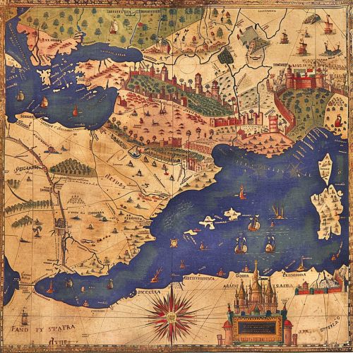
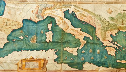
[[Image:Detail-78837.jpg|thumb|center|A detailed, colorfully illustrated Portolan chart from the 15th century, showing the Mediterranean Sea and surrounding landmasses.|class=only_on_mobile]] | |||
[[Image:Detail-78838.jpg|thumb|center|A detailed, colorfully illustrated Portolan chart from the 15th century, showing the Mediterranean Sea and surrounding landmasses.|class=only_on_desktop]] | |||
The origin of Portolan charts is still a subject of debate among historians. Some believe that they were developed by the Genoese, while others attribute their creation to the Majorcans or Catalans. Regardless of their origin, it is clear that these charts were a significant advancement in cartography and played a crucial role in maritime exploration. | The origin of Portolan charts is still a subject of debate among historians. Some believe that they were developed by the Genoese, while others attribute their creation to the Majorcans or Catalans. Regardless of their origin, it is clear that these charts were a significant advancement in cartography and played a crucial role in maritime exploration. | ||
Latest revision as of 23:10, 15 May 2024
History
The Portolan charts are a type of nautical chart, first made in the 13th century in the Mediterranean region. These charts, known for their distinctive radiating lines, were used extensively during the Age of Discovery for navigation. They were a significant improvement over the earlier Mappa Mundi style maps, which were more symbolic than accurate.


The origin of Portolan charts is still a subject of debate among historians. Some believe that they were developed by the Genoese, while others attribute their creation to the Majorcans or Catalans. Regardless of their origin, it is clear that these charts were a significant advancement in cartography and played a crucial role in maritime exploration.
Characteristics
Portolan charts are characterized by their network of rhumb lines, which radiate from various focal points known as "wind roses" or "compass roses". These lines, which represent the 32 directions of the mariner's compass, intersect at various angles to form a web-like pattern. This network of lines served as a guide for sailors, allowing them to plot a course from one point to another using the shortest possible route.
The charts also depict coastal features in great detail, including ports, cities, and landmarks. However, they lack the inland detail and scale distortion that are common in modern maps. This is because Portolan charts were designed for practical navigation rather than for representing geographical knowledge.
Construction
The construction of a Portolan chart involved several steps. First, the cartographer would draw the wind roses and the rhumb lines. Then, they would add the coastal outlines, using information from pilot books or earlier charts. Finally, they would fill in the details, such as the names of ports and landmarks.
The materials used in the construction of Portolan charts also varied. Early charts were drawn on vellum, a type of fine parchment made from calf skin. Later charts were made on paper, which was cheaper and easier to produce.
Accuracy
One of the most remarkable aspects of Portolan charts is their accuracy. Despite being made without the aid of sophisticated instruments or mathematical calculations, these charts were remarkably accurate in their depiction of coastal features. This accuracy is attributed to the practical experience of sailors, who would update and correct the charts based on their observations.
However, the accuracy of Portolan charts diminishes the further one moves from the Mediterranean. This is because the charts were based on direct observation and experience, which were limited to the areas frequented by Mediterranean sailors.
Legacy
The legacy of Portolan charts is significant. They represent a major step forward in the history of cartography, marking a shift from symbolic to practical mapping. They also played a crucial role in the Age of Discovery, aiding European explorers in their voyages to the New World.
While Portolan charts are no longer used for navigation, they continue to be studied and admired for their historical and artistic value. Many of these charts are preserved in museums and libraries around the world, serving as a testament to the skill and knowledge of the medieval mariners who created them.
