Geophysics and Its Role in Climate Change Analysis: Difference between revisions
(Created page with "== Introduction == Geophysics, the study of the Earth using quantitative physical methods, plays a crucial role in understanding and analyzing climate change. This interdisciplinary field integrates principles from physics, geology, and environmental science to investigate the Earth's structure, composition, and dynamic processes. By leveraging various geophysical techniques, scientists can monitor and model climate systems, contributing to our understanding of climate c...") |
No edit summary |
||
| Line 32: | Line 32: | ||
SAR is a type of radar that produces high-resolution images of the Earth's surface. It is used to monitor changes in land cover, ice dynamics, and surface deformation. SAR data can detect subtle changes in ice flow, glacier retreat, and permafrost thawing, providing valuable information for climate change analysis. | SAR is a type of radar that produces high-resolution images of the Earth's surface. It is used to monitor changes in land cover, ice dynamics, and surface deformation. SAR data can detect subtle changes in ice flow, glacier retreat, and permafrost thawing, providing valuable information for climate change analysis. | ||
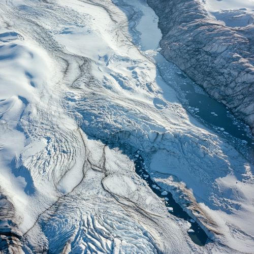
[[Image:Detail-97747.jpg|thumb|center|Aerial view of a glacier with visible crevasses and meltwater streams.|class=only_on_mobile]] | |||
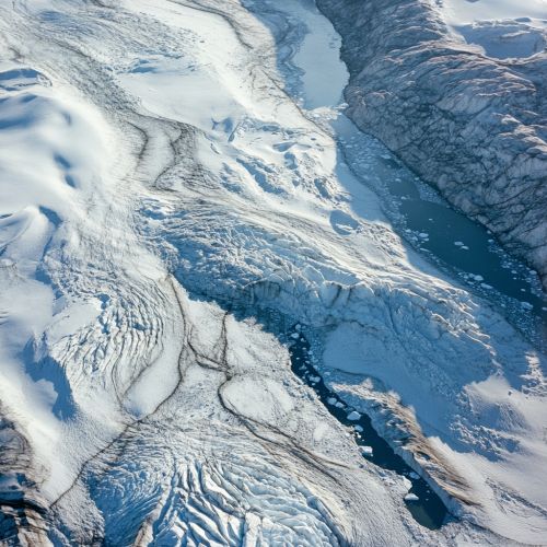
[[Image:Detail-97748.jpg|thumb|center|Aerial view of a glacier with visible crevasses and meltwater streams.|class=only_on_desktop]] | |||
== Climate Modeling and Geophysics == | == Climate Modeling and Geophysics == | ||
Latest revision as of 12:42, 30 August 2024
Introduction
Geophysics, the study of the Earth using quantitative physical methods, plays a crucial role in understanding and analyzing climate change. This interdisciplinary field integrates principles from physics, geology, and environmental science to investigate the Earth's structure, composition, and dynamic processes. By leveraging various geophysical techniques, scientists can monitor and model climate systems, contributing to our understanding of climate change and its impacts.
Geophysical Methods in Climate Change Analysis
Geophysical methods encompass a wide range of techniques used to study the Earth's physical properties. These methods can be broadly categorized into seismic, gravitational, magnetic, electrical, and electromagnetic techniques. Each of these methods provides unique insights into different aspects of the Earth's climate system.
Seismic Methods
Seismic methods involve the study of elastic waves generated by natural or artificial sources. These waves travel through the Earth and are recorded by seismometers. Seismic data can be used to infer the Earth's internal structure, including the distribution of ice and water in polar regions. This information is critical for understanding ice dynamics and predicting sea-level rise.
Gravitational Methods
Gravitational methods measure variations in the Earth's gravitational field. These variations can be caused by changes in mass distribution, such as the melting of ice sheets or the movement of tectonic plates. By analyzing gravitational data, scientists can monitor changes in ice mass and understand their contributions to sea-level rise.
Magnetic Methods
Magnetic methods involve the measurement of the Earth's magnetic field. Changes in the magnetic field can indicate variations in the Earth's crust and mantle, which can be linked to tectonic activity and volcanic eruptions. These events can influence climate by releasing greenhouse gases and aerosols into the atmosphere.
Electrical and Electromagnetic Methods
Electrical and electromagnetic methods measure the Earth's electrical conductivity. These methods are used to study the distribution of groundwater, which is essential for understanding the hydrological cycle and its impact on climate. Electromagnetic surveys can also detect permafrost thawing, which releases methane, a potent greenhouse gas.
Remote Sensing in Geophysics
Remote sensing is a critical tool in geophysics, allowing scientists to collect data over large areas and inaccessible regions. Satellites equipped with various sensors provide continuous monitoring of the Earth's surface and atmosphere, offering valuable information for climate change analysis.
Satellite Altimetry
Satellite altimetry measures the height of the Earth's surface, including sea level, ice sheets, and land elevation. This data is crucial for monitoring sea-level rise, ice sheet dynamics, and land subsidence. Altimetry data has revealed significant ice loss in Greenland and Antarctica, contributing to global sea-level rise.
Gravimetry
Gravimetry from space, such as the Gravity Recovery and Climate Experiment (GRACE) mission, measures changes in the Earth's gravitational field. This data helps scientists monitor changes in ice mass, groundwater storage, and ocean circulation. GRACE data has been instrumental in understanding the contributions of ice melt and groundwater depletion to sea-level rise.
Radiometry
Radiometry involves measuring the Earth's radiation budget, including incoming solar radiation and outgoing terrestrial radiation. This information is essential for understanding the Earth's energy balance and the role of greenhouse gases in climate change. Radiometric data from satellites like the Clouds and the Earth's Radiant Energy System (CERES) provide insights into cloud cover, albedo, and radiative forcing.
Synthetic Aperture Radar (SAR)
SAR is a type of radar that produces high-resolution images of the Earth's surface. It is used to monitor changes in land cover, ice dynamics, and surface deformation. SAR data can detect subtle changes in ice flow, glacier retreat, and permafrost thawing, providing valuable information for climate change analysis.


Climate Modeling and Geophysics
Climate models are essential tools for predicting future climate scenarios and understanding the potential impacts of climate change. Geophysical data is integral to the development and validation of these models.
Coupled Climate Models
Coupled climate models integrate the interactions between the atmosphere, oceans, land surface, and ice. These models rely on geophysical data to simulate the Earth's climate system accurately. For example, data on sea surface temperatures, ice thickness, and ocean salinity are used to model ocean circulation and its influence on climate.
Earth System Models
Earth system models (ESMs) are advanced climate models that include biogeochemical cycles, such as the carbon and nitrogen cycles. Geophysical data on soil moisture, vegetation cover, and permafrost extent are crucial for simulating these cycles and their feedbacks on climate. ESMs help predict the long-term impacts of climate change on ecosystems and the carbon cycle.
Data Assimilation
Data assimilation is the process of integrating observational data into climate models to improve their accuracy. Geophysical data from remote sensing and ground-based measurements are assimilated into models to provide real-time updates and enhance predictive capabilities. This process is essential for short-term climate forecasting and early warning systems.
Geophysical Impacts of Climate Change
Climate change has significant geophysical impacts, affecting the Earth's physical properties and processes. Understanding these impacts is crucial for assessing the risks and developing adaptation strategies.
Ice Sheet Dynamics
Climate change is causing the rapid melting of ice sheets in Greenland and Antarctica. This melting contributes to sea-level rise and alters ocean circulation patterns. Geophysical methods, such as satellite altimetry and gravimetry, are used to monitor ice sheet dynamics and predict future changes.
Permafrost Thawing
Permafrost, the permanently frozen ground in polar regions, is thawing due to rising temperatures. This thawing releases methane and carbon dioxide, potent greenhouse gases that exacerbate climate change. Geophysical techniques, such as electrical resistivity and ground-penetrating radar, are used to study permafrost extent and monitor thawing.
Ocean Circulation
Climate change affects ocean circulation patterns, such as the Atlantic Meridional Overturning Circulation (AMOC). Changes in ocean circulation can influence global climate by altering heat and nutrient distribution. Geophysical data on sea surface temperatures, salinity, and ocean currents are essential for understanding these changes and their impacts.
Seismic Activity
Climate change can influence seismic activity by altering the distribution of mass on the Earth's surface. For example, the melting of ice sheets can reduce pressure on tectonic plates, potentially triggering earthquakes and volcanic eruptions. Seismic monitoring is crucial for assessing these risks and understanding the links between climate change and seismic activity.
Geophysical Monitoring Networks
Geophysical monitoring networks are essential for collecting continuous data on the Earth's physical properties. These networks provide valuable information for climate change analysis and early warning systems.
Seismic Networks
Seismic networks consist of seismometers distributed globally to monitor earthquakes and other seismic events. These networks provide data on tectonic activity, volcanic eruptions, and ice dynamics. Seismic data is crucial for understanding the geophysical impacts of climate change and assessing associated risks.
Gravimetric Networks
Gravimetric networks measure variations in the Earth's gravitational field using ground-based and satellite instruments. These networks monitor changes in ice mass, groundwater storage, and ocean circulation. Gravimetric data is essential for understanding the contributions of ice melt and groundwater depletion to sea-level rise.
Magnetic Networks
Magnetic networks measure the Earth's magnetic field using ground-based and satellite instruments. These networks provide data on tectonic activity, volcanic eruptions, and changes in the Earth's crust and mantle. Magnetic data is crucial for understanding the geophysical impacts of climate change and assessing associated risks.
Remote Sensing Networks
Remote sensing networks consist of satellites equipped with various sensors to monitor the Earth's surface and atmosphere. These networks provide continuous data on sea level, ice sheets, land cover, and atmospheric composition. Remote sensing data is essential for climate change analysis and the development of predictive models.
Future Directions in Geophysical Research
Geophysical research is continually evolving, with new technologies and methods being developed to improve our understanding of climate change. Future directions in geophysical research include:
Advanced Remote Sensing Technologies
The development of advanced remote sensing technologies, such as hyperspectral imaging and lidar, will provide more detailed and accurate data on the Earth's surface and atmosphere. These technologies will enhance our ability to monitor climate change and its impacts.
Integrated Monitoring Systems
Integrated monitoring systems that combine data from multiple geophysical methods will provide a more comprehensive understanding of the Earth's climate system. These systems will improve the accuracy of climate models and enhance predictive capabilities.
Machine Learning and Data Analytics
The application of machine learning and data analytics to geophysical data will enable the identification of patterns and trends that are not apparent through traditional analysis. These techniques will improve our ability to predict climate change impacts and develop effective adaptation strategies.
Interdisciplinary Research
Interdisciplinary research that integrates geophysics with other fields, such as biology, chemistry, and social sciences, will provide a more holistic understanding of climate change. This approach will enhance our ability to address the complex challenges posed by climate change and develop sustainable solutions.
Conclusion
Geophysics plays a vital role in climate change analysis by providing critical data on the Earth's physical properties and processes. Through the use of various geophysical methods and remote sensing technologies, scientists can monitor and model climate systems, contributing to our understanding of climate change and its impacts. Continued advancements in geophysical research will enhance our ability to predict and mitigate the effects of climate change, ensuring a sustainable future for our planet.
