Central Arizona Project: Difference between revisions
(Created page with "== Overview == The Central Arizona Project (CAP) is a significant water diversion and delivery system in the southwestern United States, specifically designed to transport water from the Colorado River to central and southern Arizona. The project plays a crucial role in providing a reliable water supply to the arid regions of Arizona, supporting agricultural, municipal, and industrial water needs. == History == The concept of the Central Arizona Project dates back to th...") |
No edit summary |
||
| Line 20: | Line 20: | ||
The CAP system incorporates several reservoirs that serve as storage and regulation points. The largest of these is Lake Pleasant, which has a storage capacity of approximately 1.1 million acre-feet. Other significant reservoirs include the New Waddell Dam and the Agua Fria River Basin. | The CAP system incorporates several reservoirs that serve as storage and regulation points. The largest of these is Lake Pleasant, which has a storage capacity of approximately 1.1 million acre-feet. Other significant reservoirs include the New Waddell Dam and the Agua Fria River Basin. | ||
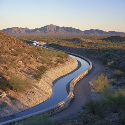
[[Image:Detail-97697.jpg|thumb|center|Central Arizona Project aqueduct winding through the desert landscape.|class=only_on_mobile]] | |||
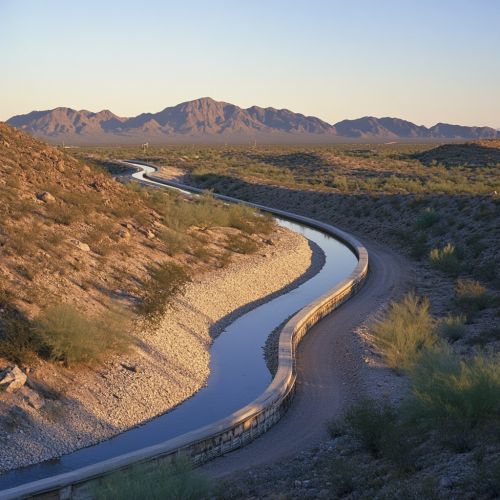
[[Image:Detail-97698.jpg|thumb|center|Central Arizona Project aqueduct winding through the desert landscape.|class=only_on_desktop]] | |||
== Water Allocation and Management == | == Water Allocation and Management == | ||
Latest revision as of 08:48, 19 August 2024
Overview
The Central Arizona Project (CAP) is a significant water diversion and delivery system in the southwestern United States, specifically designed to transport water from the Colorado River to central and southern Arizona. The project plays a crucial role in providing a reliable water supply to the arid regions of Arizona, supporting agricultural, municipal, and industrial water needs.
History
The concept of the Central Arizona Project dates back to the early 20th century, with initial discussions and proposals emerging as early as the 1920s. However, it wasn't until the passage of the Colorado River Basin Project Act in 1968 that the CAP was officially authorized by the United States Congress. The construction of the project began in 1973 and was completed in stages over the following decades, with the final phase being completed in 1993.
Infrastructure
The Central Arizona Project spans approximately 336 miles (541 kilometers) from its intake at Lake Havasu on the Colorado River to its terminus south of Tucson. The infrastructure includes a series of aqueducts, tunnels, pumping stations, and reservoirs designed to transport and store water efficiently.
Aqueducts
The CAP aqueduct system is a complex network of open channels and pipelines that convey water across varied terrain. The main aqueduct is constructed of concrete and lined with materials to minimize water loss through seepage and evaporation.
Pumping Stations
To overcome the elevation changes along its route, the CAP relies on 14 pumping stations. These stations lift the water over significant elevation gains, including the critical lift over the Buckskin Mountains. The Mark Wilmer Pumping Plant, located near Lake Havasu, is the first and most powerful of these stations, capable of lifting water 824 feet (251 meters).
Tunnels
The project includes several tunnels that allow the aqueduct to pass through mountainous regions. Notable tunnels include the Buckskin Mountain Tunnel and the Bouse Hills Tunnel, which are engineering feats in their own right.
Reservoirs
The CAP system incorporates several reservoirs that serve as storage and regulation points. The largest of these is Lake Pleasant, which has a storage capacity of approximately 1.1 million acre-feet. Other significant reservoirs include the New Waddell Dam and the Agua Fria River Basin.


Water Allocation and Management
The CAP is a critical component of Arizona's water management strategy, providing water to various sectors under a complex allocation system. The water is divided among agricultural users, municipal and industrial users, and Native American tribes.
Agricultural Use
Agriculture is a significant beneficiary of CAP water, particularly in the fertile regions of Pinal and Maricopa counties. The water supports the irrigation of crops such as cotton, alfalfa, and citrus, which are essential to the state's economy.
Municipal and Industrial Use
Urban areas, including Phoenix and Tucson, rely heavily on CAP water for their municipal and industrial needs. The project ensures a stable water supply for residential consumption, commercial activities, and industrial processes.
Native American Tribes
Several Native American tribes have secured water rights through the CAP, including the Ak-Chin Indian Community and the Gila River Indian Community. These rights are critical for supporting the tribes' agricultural and economic development.
Environmental Impact
The construction and operation of the Central Arizona Project have had significant environmental implications. The diversion of water from the Colorado River has affected the river's flow and ecosystem. Additionally, the project has led to changes in land use and habitat in the regions it serves.
Colorado River Ecosystem
The reduction in flow to the Colorado River has impacted its delta and the species that depend on the river's ecosystem. Efforts are ongoing to mitigate these impacts through various conservation and restoration programs.
Habitat Changes
The introduction of a reliable water supply has transformed arid landscapes into productive agricultural and urban areas. While this has economic benefits, it has also led to habitat loss and changes in local biodiversity.
Legal and Political Aspects
The Central Arizona Project is governed by a complex web of legal agreements and political considerations. The allocation of water from the Colorado River is subject to interstate compacts, federal laws, and court decisions.
Colorado River Compact
The Colorado River Compact of 1922 is a foundational agreement that divides the river's water among the seven basin states. The compact plays a crucial role in determining the amount of water available to the CAP.
Federal Legislation
The Colorado River Basin Project Act of 1968 authorized the construction of the CAP and established guidelines for its operation. Subsequent legislation and amendments have further refined these guidelines.
Interstate and International Relations
The CAP's operation affects not only Arizona but also other states in the Colorado River Basin and Mexico. Interstate agreements and international treaties govern the distribution and management of the river's water.
Future Challenges
The Central Arizona Project faces several challenges as it looks to the future. These include water scarcity, climate change, and the need for sustainable water management practices.
Water Scarcity
The Colorado River Basin is experiencing prolonged drought conditions, which have reduced the river's flow and the availability of water for the CAP. This scarcity necessitates careful management and conservation efforts.
Climate Change
Climate change is expected to exacerbate water scarcity in the region by altering precipitation patterns and increasing temperatures. The CAP must adapt to these changes to ensure a reliable water supply.
Sustainable Management
Ensuring the long-term sustainability of the CAP requires innovative management practices, including water recycling, desalination, and the use of alternative water sources. Collaboration among stakeholders is essential to address these challenges.
